TurfScore
Know your course at a glance.
Keeping a golf course in top shape has always relied on experience and a trained eye. Turf Score adds a complete picture of your course's health, updated with every flight, so your expertise has a baseline to build on.
One simple score tells the story.
Turf Score translates the condition of your course into simple, three-digit numbers. Each green, fairway, rough area, and tee box receives its own score, and those combine into an overall score for every hole and for the course as a whole. Higher numbers mean healthier turf. There are no charts to interpret and no sensor readings to decipher. Anyone on your team can look at the scores and understand them in seconds.
See it early.
Turf Score reads the earliest signs of change, such as dryness, disease, or wear, often 2-3 weeks before they show on the ground, so you can lead the surface forward. Water, product, equipment, and people go only where they're needed.
Your course, wherever you are.
Scores update with every flight and are available on any phone, tablet, or computer. Whether you're in the maintenance shop, at home, or traveling, you and your team see the same picture from the latest flight, so everyone works from the same information.
Better decisions over time.
Turf Score keeps a running history of your course's health. You can see which applications worked, show measurable results to your board or committee, and plan next season with real numbers behind you. The course stays in peak condition, and your team spends less time guessing.
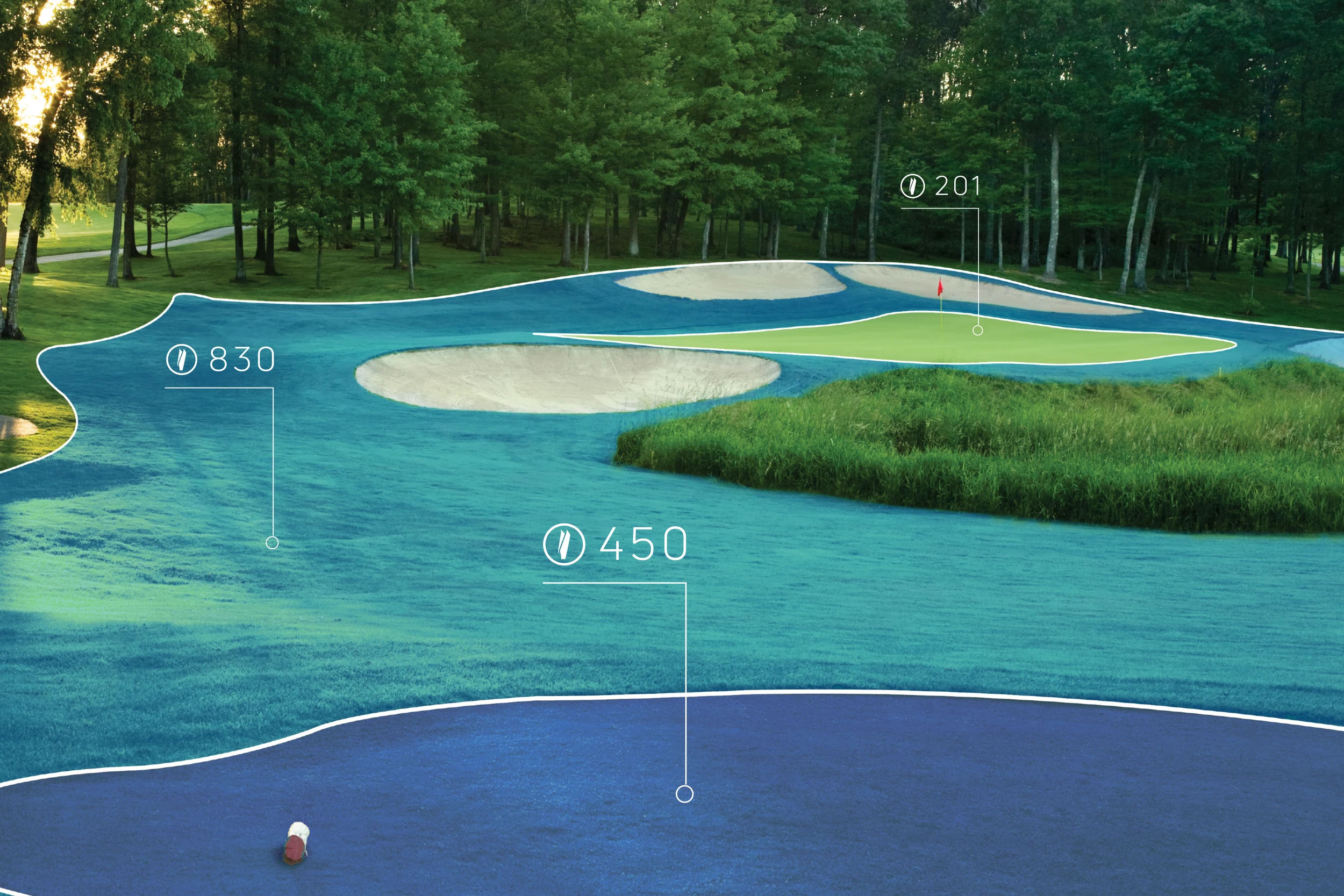
Feature Based Scoring gives every hole on your course a condition score, plus separate scores for the greens, fairways, rough, and tee boxes on that hole. You can see at a glance which surfaces are healthy and which need attention, without walking the property or interpreting imagery. If the fourth green starts slipping while everything around it holds steady, the score tells you before a golfer does.
Digital Twin
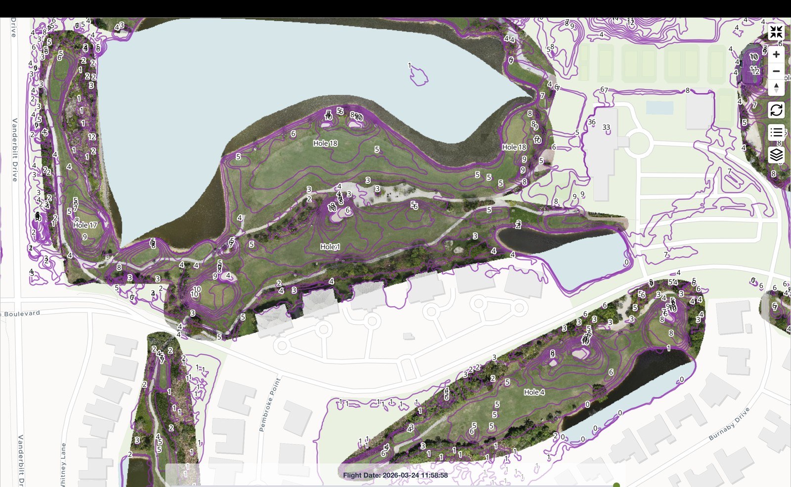
Every superintendent carries a mental map of their course, but a mental map cannot be measured, shared, or checked from home. The Digital Twin is a complete digital copy of your golf course, recreated in exact detail. Every fairway, green, bunker, and contour is there, and the model updates with every drone flight, so it shows your course as of the latest flight.
Turf health, water movement, and wear patterns are layered directly into the model. Instead of jumping between reports, photos, and notes, you get one clear picture of the whole property. Zoom out to see the entire course or zoom in on a single green, all from your phone, tablet, or computer.
When it is time to work with an architect, engineer, or consultant, you can hand them the full course model instead of scheduling site visits or digging up old drawings. Everyone works from the same accurate, up-to-date view of the property. New drainage, renovations, and construction projects can be measured and planned right inside the model, so you can scope the work, compare options, and make decisions with real numbers behind you before anyone breaks ground.
The result is less guesswork and more clarity. Your course, your data, and your plans all live in one accurate model that grows with your property and keeps members and management confident in every decision.
History Tracker
Every flight you save builds the story of your course: day by day, week by week, year by year. Identify the change you want, make it, fly again, and measure: did the score move, did the stress shrink, did the treatment work? Scroll back and see what changed, which programs worked, and how far you've come. One flight is a data point. A season of flights is a story. A career of flights is a living resume: documented improvements so your name and your course rise together with proof.
Stress Maps
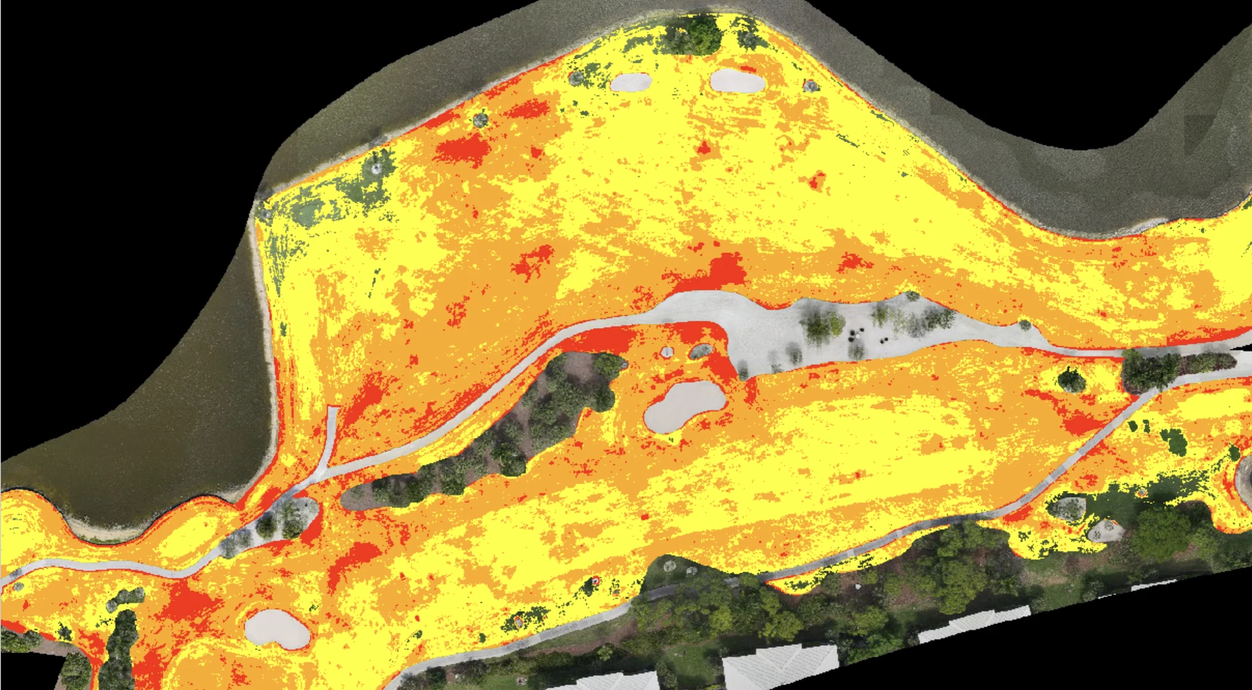
Stress Maps put you 2-3 weeks ahead of what the ground will show, so you can lead the course toward the surface you want while it still looks its best. After every drone flight, your entire course is painted in color: green is thriving turf, yellow is stress no eye can catch yet, orange is stress you can see, and red is turf that needs you now.
Think of it as a weather radar for your turf. The map lays a color overlay on top of a crisp aerial photo of your course. Where the turf is healthy, you simply see your course exactly as it looks from above, with no color at all. Where stress is building, the map lights up.
The maps cover every part of the property: greens, fairways, tee boxes, and rough. That means your crew can go straight to the exact spots that will move the course forward.
Stress Maps also confirm the work. After your team sprays or fertilizes, the next flight shows whether the application covered everything evenly. As the treatments take effect, you can watch the color fade back to green, clear evidence that the plan is working and that labor, water, and materials are going where they do the most good.
The result is a course led with confidence. You act on facts, see change while it is still invisible, and keep your playing surfaces at their best all year long.
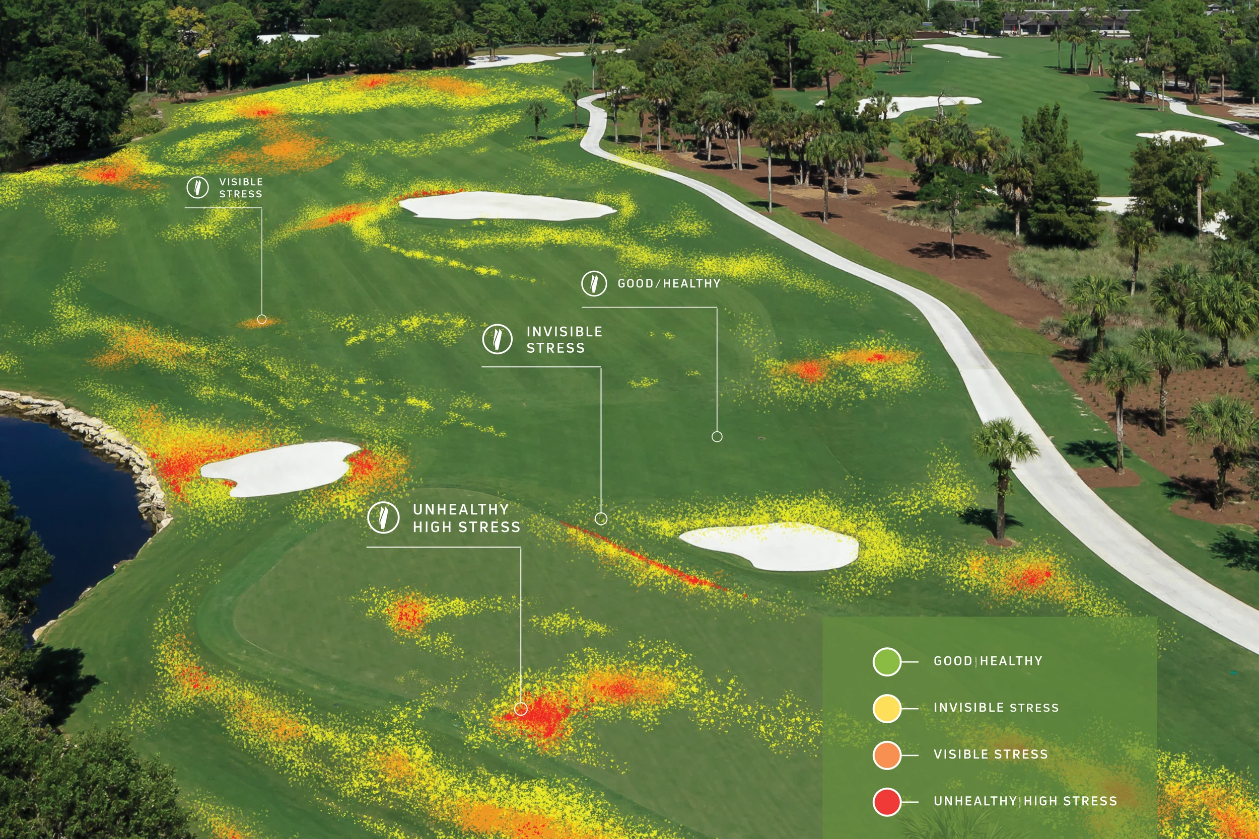
Healthy (No Color)
Where the turf is healthy, you simply see your course exactly as it looks from above, with no color at all.
Invisible (Yellow)
Yellow is stress no eye can catch yet, 2-3 weeks before it shows. This is where great superintendents win, because a small adjustment now keeps the surface on the standard you set.
Visible (Orange)
Orange is stress you can see. A focused plan brings the color back toward green.
Unhealthy (Red)
Red is turf that is ready for your attention now.
Irrigation Mapping
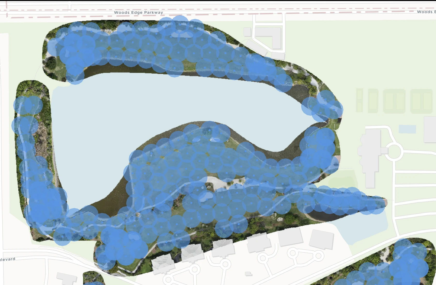
Every sprinkler head and its coverage, mapped onto your Digital Twin. See which heads run too long, too short, or exactly right. Overlay the map with stress and soil moisture and you know which areas are turf and which are water.
Mapped at a glance.
Every sprinkler head is geo-located on a live GIS map. Coverage radiuses show exactly where water reaches, and where it doesn't.
Remote Monitoring
The condition of a golf course used to live in one place: the head of the person managing it. Turflogic changes that by keeping everything it learns about your course in the cloud, where it can be reached from any computer or tablet. Your superintendent does not have to be in the office to check on the turf. If something looks off in the morning's data, they can take a tablet out on a cart and drive straight to the spot in question.
Just as useful is who else can see it. Courses often rely on outside help, whether that is an agronomist, a consultant, or the supplier who provides chemicals and equipment. With Turflogic, you can give those experts access to your course data directly. They see the same maps and history your team sees, so their recommendations are grounded in what is actually happening on your turf. For owners and management groups running more than one property, this becomes a way to keep an eye on all of them at once, compare how each is doing, and make sure a lesson learned at one course benefits the rest. Tablet access does require an internet connection to view course data, which is worth noting for crews working in areas with spotty coverage.
Construction Management
CAD files, Laser Scanning and Contour Maps
While Digitizing your course, our equipment takes hundreds of readings per square meter, creating contour lines and contour maps. Sprinkler system mapping, throws, and their radiuses are displayed, if available. LIDAR technology allows us to create detailed shape files, high resolution scanning and contour mapping. The files and mapping we create can be provided to civil engineers and architects for any future construction projects.
Contour maps and contour lines provide an in-depth, accurate representation of your land’s natural features. This allows for precise measurements of elevation, gradients, and surface characteristics, which are essential for anyone involved in land development or project planning.
LiDAR scanning also produces a wealth of data, including detailed shape files that can be integrated directly into architectural and engineering software. For civil engineers, architects, and land planners, this means having access to highly accurate digital models that are ready for immediate use in design and development. The ability to generate these digital maps and models saves significant time and resources compared to traditional surveying methods, providing a faster, more efficient way to plan for construction or landscaping.
Sub-centimeter accuracy LiDAR, flown on a dedicated drone during onboarding, turns your property into a survey-grade Digital Twin on day one. Shape files load into GPS sprayers and autonomous mowers, and go straight to your engineer or architect when you renovate. No surveyor. No waiting weeks for a quote. One model. Every corner measured. From day one.
The drone sees the surface.
Metos sees the subsurface.
A non-contact scanner on your maintenance vehicle reads moisture, conductivity, salinity, and compaction through the root zone plus 3 feet as you drive your normal routes. Layer that with Turflogic stress maps and you learn which areas are moisture and which are turf.